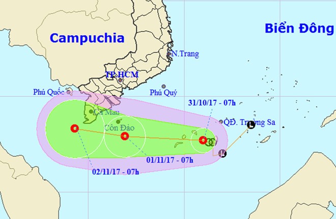
The low pressure area in the East Sea (South China Sea) has strengthened into a tropical depression, causing bad weather in the southern coastal provinces.

A representation of the direction of the tropical depression. — Photo nchmf.gov.vn
The National Centre for Hydro-meteorological Forecasting (NCHMF), in its report on Tuesday, said that the tropical depression was located right on the southwestern part of the Spratly Islands, with winds expected to reach 60km per hour.
Tonight, the tropical depression is forecast to move west at 15km to 20km per hour and approach the southern provinces of Bến Tre and Cà Mau’s coastal area on Wednesday. Wind level will remain unchanged.
Tropical depression and cold air will cause rain, thunderstorm, cyclone and tornado in the Spratly Islands’ southwestern area and the waters from Bình Thuận to Cà Mau Province, including the islands of Phú Quý and Côn Đảo.
By Wednesday, the central coastal provinces may experience rains, showers and even thunderstorms. Rainfall of 50mm to 150mm is forecast, and in the central southern provinces of Quảng Nam, Quảng Ngãi and Bình Định, it may reach 200mm.
Due to the effect of the tropical circulation, from Tuesday night to Thursday, there will be rain in the south with rainfall of 100mm to 150mm. Cyclones, tornados and strong winds of level 7 to 8 (of 18) are expected.
Water level of Cửu Long (Mekong) River and Sài Gòn River is rising. Therefore, the tide may flood low areas, riverside areas and areas outside dike systems of HCM City, Cần Thơ City and Vĩnh Long Province.
According to the NCHMF, the Philippines’ central area is witnessing a tropical depression. It was about 1,200 km east from Palawan Island at 7am on Tuesday. The tropical depression is strengthening and moving west at 15km per hour. It may enter the East Sea area on Thursday. — VNS